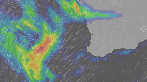
<div class="block-content"><div class="styles__Container-sc-1ylecsg-0 goULFa"><span>An "unusually strong" weather system which could even bring tornadoes is set to lash parts of Western Australia over the weekend.</span></div></div><div class="block-content"><div class="styles__Container-sc-1ylecsg-0 goULFa"><span>A severe weather warning is in place for a large area from about Kalbarri in the north, down south to Margaret River and out towards the south-east coast of the state.</span></div></div><div class="block-content"><div class="styles__Container-sc-1ylecsg-0 goULFa"><span>Bureau of Meteorology meteorologist Ilana Cherny said the system would bring damaging to destructive wind gusts, heavy falls, very large waves and potentially localised tornadoes.</span></div></div><div><div id="adspot-mobile-medium"></div></div><div class="block-content"><div class="styles__Container-sc-1ylecsg-0 goULFa"><strong><span>READ MORE:</span></strong><span> </span><a href="https://www.9news.com.au/national/sexism-in-schools-rising-boys-target-female-teachers-students/086fc49c-0218-4f03-a855-ca87f57cd2ce"><strong><span>Alarm over scary trend 'exploding' in Aussie schools</span></strong></a><span></span></div></div><div class="block-content"><div class="styles__Container-sc-1ylecsg-0 goULFa"><span>"The risk of those hazards begins this evening as showers and thunderstorms start to move through," Cherny said.</span></div></div><div class="block-content"><div class="styles__Container-sc-1ylecsg-0 goULFa"><span>"Starting from Kalbarri and the central west this evening, extending through the lower west and south-west through the early hours of tomorrow morning.</span></div></div><div class="block-content"><div class="styles__Container-sc-1ylecsg-0 goULFa"><span>"The risk of damaging winds will extend further east throughout Sunday."</span></div></div><div><div class="OUTBRAIN" data-reactroot="" data-src="//www.9news.com.au/national/wa-weather-unusually-strong-system-could-bring-destructive-winds-heavy-falls-and-localised-tornadoes-for-western-australia/6bcc2234-b7b7-472d-9f48-6ed97e3c4e59" data-widget-id="AR_5"></div></div><div class="block-content"><div class="styles__Container-sc-1ylecsg-0 goULFa"><span>Cherny said there would be a second burst of "very strong winds" with a risk of locally destructive gusts from about Lancelin to Albany.</span></div></div><div class="block-content"><div class="styles__Container-sc-1ylecsg-0 goULFa"><span>"That risk will be for Sunday evening into Monday morning," she said.</span></div></div><div class="block-content"><div class="styles__Container-sc-1ylecsg-0 goULFa"><span>Severe thunderstorms could develop through the central west and extending through to the lower west.</span></div></div><div class="block-content"><div class="styles__Container-sc-1ylecsg-0 goULFa"><span>"In addition to those winds and rain which we could see with the thunderstorms, we may also see some very localised tornadoes, which if they develop would be very fast-moving and short-lived."</span></div></div><div class="block-content"><div class="styles__Container-sc-1ylecsg-0 goULFa"><span>Residents are advised to stay up to date with the latest warnings on the </span><a href="https://www.bom.gov.au/weather-and-climate/warnings-and-alerts" rel="nofollow" target="_blank" title="Bureau of Meteorology"><span>Bureau of Meteorology</span></a><span> website.</span></div></div>
Tornadoes possible as 'strong' weather system hits WA
Leave A Reply
Your email address will not be published.*