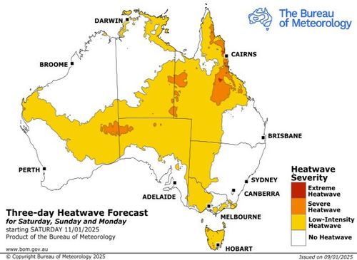
<div class="block-content"><div class="styles__Container-sc-1ylecsg-0 goULFa"><span>Temperatures will soar into the mid-40s as severe and intense heatwaves are forecast for inland Australia this weekend, while parts of the northern and eastern coasts are expected to be lashed with thunderstorms and heavy rainfall.</span></div></div><div class="block-content"><div class="styles__Container-sc-1ylecsg-0 goULFa"><span>The Bureau of Meteorology has issued heatwave warnings for most of the Northern Territory, inland areas of Queensland and Western Australia, western Tasmania, and parts of South Australia over the next two days.</span></div></div><div class="block-content"><div class="styles__Container-sc-1ylecsg-0 goULFa"><span>The Northern Territory's south-east corner, Western Australia's South Interior and South Australia's North West Pastoral District can expect maximum temperatures in the low to mid 40s and overnight minimums in the mid to high 20s.</span></div></div><div><div id="adspot-mobile-medium"></div></div><div class="block-content"><div class="styles__Container-sc-1ylecsg-0 goULFa"><strong><span>READ MORE:</span></strong><span> </span><a href="https://www.9news.com.au/world/la-fires-2025-what-started-it-everything-to-know-explainer/2542c14a-1c3c-476b-9beb-9db0a9d17fef" target="_blank"><strong><span>Here's why LA's ferocious wildfires are burning in the middle of winter</span></strong></a></div></div><div class="tweet" data-tweet-id="1877220342638289058?ref_src=twsrc%5Etfw" data-user="9NewsAUS"></div><div class="block-content"><div class="styles__Container-sc-1ylecsg-0 goULFa"><span>Queensland's Channel Country can expect similar conditions on the weekend but severe heatwave conditions will continue to build into next week, with overnight temperatures in the low 30s.</span></div></div><div class="block-content"><div class="styles__Container-sc-1ylecsg-0 goULFa"><span>According to Weatherzone, temperatures could reach 46 to 47 degrees celsius in parts of far western Qld during the first half of next week, while temperatures are also predicted to hit 45 to 46°C in the north of SA and the southern NT.</span></div></div><div class="block-content"><div class="styles__Container-sc-1ylecsg-0 goULFa"><span>Tasmania can expect maximum temperatures in the high 20s to low 30s and overnight minimum temperatures in the low to mid teens over the weekend, with severe heatwave conditions over the North West Coast and Furneaux Islands easing early next week.</span></div></div><div><div class="OUTBRAIN" data-reactroot="" data-src="//www.9news.com.au/national/australia-weather-heatwave-forecast-for-vast-swathe-of-the-country-across-the-weekend/917d7c53-e7a8-4790-8bdd-8faebe90d9fb" data-widget-id="AR_5"></div></div><div class="block-content"><div class="styles__Container-sc-1ylecsg-0 goULFa"><span>With the scorching heat comes a high fire danger rating for most of South Australia and Western Australia across the weekend.</span></div></div><div class="block-content"><div class="styles__Container-sc-1ylecsg-0 goULFa"><span>While the interior swelters, on the east coast, Sydney, Brisbane and the Gold Coast are in for a wet weekend with storms and showers forecast across both days.</span></div></div><div class="block-content"><div class="styles__Container-sc-1ylecsg-0 goULFa"><strong><span>READ MORE:</span></strong><span> </span><a href="https://www.9news.com.au/national/weather-news-queensland-storm-warning-national-weather-forecast-eastern-australia/0dd35ebe-3fb2-4b06-95b2-16faed50b647" rel="" target="" title="Rainbomb hits Brisbane, Gold Coast with more storms on the way"><strong><span>Rainbomb hits Brisbane, Gold Coast with more storms on the way</span></strong></a></div></div><div class="block-content"><div class="styles__Container-sc-1ylecsg-0 goULFa"><span>Severe weather warnings are in place currently for much of Queensland's south-east inland with heavy rainfall forecast for the Wide Bay and Burnett, Southeast Coast and Darling Downs and Granite Belt districts.</span></div></div><div class="block-content"><div class="styles__Container-sc-1ylecsg-0 goULFa"><span>Early this morning, Herring Lagoon on North Stradbroke Island recorded 93mm in an hour.</span></div></div><div class="block-content"><div class="styles__Container-sc-1ylecsg-0 goULFa"><span>47mm was recorded at Holmleigh, near Mitchell in the Maranoa, in the hour to 10.30am.</span></div></div><div class="block-content"><div class="styles__Container-sc-1ylecsg-0 goULFa"><a href="https://www.9news.com.au/national/how-to-follow-9news-digital/29855bb1-ad3d-4c38-bc25-3cb52af1216f" target="_blank"><strong><em><span>DOWNLOAD THE 9NEWS APP</span></em></strong></a><strong><em><span>: Stay across all the latest in breaking news, sport, politics and the weather via our news app and get notifications sent straight to your smartphone. Available on the</span></em></strong><span> </span><a href="https://apps.apple.com/au/app/9news/id1010533727" target="_blank"><strong><em><span>Apple App Store</span></em></strong></a><span> </span><strong><em><span>and</span></em></strong><span> </span><a href="https://play.google.com/store/apps/details?id=nineNewsAlerts.nine.com&hl=en_AU&pli=1" target="_blank"><strong><em><span>Google Play</span></em></strong></a><strong><em><span>.</span></em></strong></div></div>
Heatwaves forecast for vast swathe of the country across the weekend

Leave A Reply
Your email address will not be published.*