<div class="block-content"><div class="styles__Container-sc-1ylecsg-0 goULFa"><span>A blast of wintry </span><a href="https://www.9news.com.au/weather" rel="" target="" title="weather"><span>weather</span></a><span> will sweep across southeastern Australia from tomorrow, bringing </span><a href="https://www.9news.com.au/snow" rel="" target="" title="snow"><span>snow</span></a><span>, gusty winds and a burst of much colder conditions after an unseasonably mild autumn.</span></div></div><div class="block-content"><div class="styles__Container-sc-1ylecsg-0 goULFa"><span>It follows a soaking start to the week, with parts of </span><a href="https://www.9news.com.au/victoria" rel="" target="" title="Victoria"><span>Victoria</span></a><span> and </span><a href="https://www.9news.com.au/new-south-wales" rel="" target="" title="New South Wales"><span>New South Wales</span></a><span> recording their wettest May days in years.</span></div></div><div class="block-content"><div class="styles__Container-sc-1ylecsg-0 goULFa"><span>Another, stronger front will move in from tomorrow and into Thursday, sending icy air north and bringing the coldest conditions of the season so far.</span></div></div><div><div id="adspot-mobile-medium"></div></div><div class="block-content"><div class="styles__Container-sc-1ylecsg-0 goULFa"><strong><span>READ MORE:</span></strong><span> </span><a href="https://www.9news.com.au/national/federal-budget-2026-what-to-expect-signficant-changes-announcements-explainer/94106a49-6102-447d-bb6a-53aabc1d4a5f"><strong><span>Aussies could be $300 richer in one-off tax relief measure</span></strong></a></div></div><div class="block-content"><div class="styles__Container-sc-1ylecsg-0 goULFa"><h3><span>NSW</span></h3></div></div><div class="block-content"><div class="styles__Container-sc-1ylecsg-0 goULFa"><span>Rain has already swept across large parts of the state, with heavy falls recorded in the Snowy Mountains and central west.</span></div></div><div class="block-content"><div class="styles__Container-sc-1ylecsg-0 goULFa"><span>Thredbo Top Station recorded 106mm of rain in just 24 hours on Sunday – its wettest May day on record – while Cabramurra and Forbes also saw significant totals.</span></div></div><div><div class="OUTBRAIN" data-reactroot="" data-src="//www.9news.com.au/national/wintry-cold-blast-weather-forecast-may-snow-hail-wind/b01641bb-1682-4930-9c74-e05967150747" data-widget-id="AR_5"></div></div><div class="block-content"><div class="styles__Container-sc-1ylecsg-0 goULFa"><span>Showers are continuing across eastern parts of the state, including in Sydney, ahead of the cool change.</span></div></div><div class="block-content"><div class="styles__Container-sc-1ylecsg-0 goULFa"><span>Colder air will deepen from Thursday, with snow expected to fall across the alpine region and possibly onto the tablelands.</span></div></div><div class="block-content"><div class="styles__Container-sc-1ylecsg-0 goULFa"><span>Sydney will escape the worst of the cold temperatures, but temperatures are expected to fall to a high of 18 degrees on Thursday.</span></div></div><div class="block-content"><div class="styles__Container-sc-1ylecsg-0 goULFa"><span>Canberra is forecast to reach just 10 degrees, with frost likely heading into the weekend.</span></div></div><div class="block-content"><div class="styles__Container-sc-1ylecsg-0 goULFa"><h3><span>Victoria</span></h3></div></div><div class="block-content"><div class="styles__Container-sc-1ylecsg-0 goULFa"><span>Widespread rain has soaked much of the state, with alpine areas recording the heaviest falls.</span></div></div><div class="block-content"><div class="styles__Container-sc-1ylecsg-0 goULFa"><span>The heaviest falls were at Mount Hotham, which received more than 80mm in 24 hours, while nearby Harrietville and Mount Buffalo also saw substantial totals.</span></div></div><div class="block-content"><div class="styles__Container-sc-1ylecsg-0 goULFa"><span>Central and western districts recorded solid falls, with several locations posting their highest May daily totals in years.</span></div></div><div class="block-content"><div class="styles__Container-sc-1ylecsg-0 goULFa"><span>Melbourne has enjoyed a long run of mild days, topping 20 degrees on most days over the past fortnight.</span></div></div><div class="block-content"><div class="styles__Container-sc-1ylecsg-0 goULFa"><span>That run is about to end with a maximum temperature of 12 degrees forecast for Thursday.</span></div></div><div class="block-content"><div class="styles__Container-sc-1ylecsg-0 goULFa"><span>Showers, strong winds and colder temperatures are expected to linger into the weekend.</span></div></div><div class="block-content"><div class="styles__Container-sc-1ylecsg-0 goULFa"><h3><span>Tasmania</span></h3></div></div><div class="block-content"><div class="styles__Container-sc-1ylecsg-0 goULFa"><span>Northern parts of the state were caught up in the weekend rain, while colder conditions are set to return as the stronger front moves through.</span></div></div><div class="block-content"><div class="styles__Container-sc-1ylecsg-0 goULFa"><span>Hobart is forecast to reach just 13 degrees on Thursday, with snow expected on higher ground.</span></div></div><div class="block-content"><div class="styles__Container-sc-1ylecsg-0 goULFa"><span>Tasmania has already seen several snowfall events this autumn, but this system will deliver another burst of wintry weather.</span></div></div><div class="block-content"><div class="styles__Container-sc-1ylecsg-0 goULFa"><h3><span>What to expect</span></h3></div></div><div class="block-content"><div class="styles__Container-sc-1ylecsg-0 goULFa"><span>The incoming front will bring a mix of showers, small hail and strong winds as it tracks across the southeast.</span></div></div><div class="block-content"><div class="styles__Container-sc-1ylecsg-0 goULFa"><span>Snow is forecast to fall to altitudes of around 900 metres, with up to 20cm possible across alpine resorts in Victoria and New South Wales.</span></div></div><div class="block-content"><div class="styles__Container-sc-1ylecsg-0 goULFa"><span>The falls are unlikely to last, however, with conditions expected to ease before the traditional ski season begins in early June.</span></div></div><div class="block-content"><div class="styles__Container-sc-1ylecsg-0 goULFa"><span>While parts of the mainland have seen brief snow earlier this autumn, this system is shaping up to be the strongest cold outbreak so far this year.</span></div></div><div class="block-content"><div class="styles__Container-sc-1ylecsg-0 goULFa"><strong><em><span>NEVER MISS A STORY:</span></em></strong><span> </span><em><span>Get your breaking news and exclusive stories first by following us across all platforms.</span></em></div></div><div class="block-content"><div class="styles__Container-sc-1ylecsg-0 goULFa"><ul><li><strong><em><span>Download the 9NEWS App here via</span></em></strong><span> </span><a href="https://apps.apple.com/au/app/9news/id1010533727" target="_blank"><strong><em><span>Apple</span></em></strong></a><span> </span><strong><em><span>and</span></em></strong><span> </span><a href="https://play.google.com/store/apps/details?id=nineNewsAlerts.nine.com&hl=en_AU&pli=1" target="_blank"><strong><em><span>Google Play</span></em></strong></a></li><li><strong><em><span>Make 9News your preferred source on Google by</span></em></strong><span> </span><a href="https://9.nine.com.au/8x987w" target="_blank"><strong><em><span>ticking this box here</span></em></strong></a></li><li><strong><em><span>Sign up to</span></em></strong><span> </span><a href="https://login.nine.com.au/edm?client_id=nineatnine" target="_blank"><strong><em><span>our breaking newsletter here</span></em></strong></a></li></ul></div></div>
Snow, hail and icy winds to lash southeast in sudden cold snap
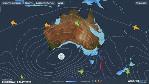
Leave A Reply
Your email address will not be published.*