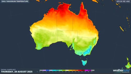
<div class="block-content"><div class="styles__Container-sc-1ylecsg-0 goULFa"><span>The final days of winter are shaping to bring massive contrasts in daytime temperatures across Australia of 40 degrees or more.</span></div></div><div class="block-content"><div class="styles__Container-sc-1ylecsg-0 goULFa"><span>In parts of south-eastern states, the mercury will struggle to lift above zero, while in northern Australia, temperatures are forecast to hit 40 degrees, Weatherzone reports.</span></div></div><div class="block-content"><div class="styles__Container-sc-1ylecsg-0 goULFa"><span>Tasmania, Victoria, South Australia, the ACT and south-western NSW are being blanketed by a frigid polar air mass that will send temperatures plunging from today.</span></div></div><div><div id="adspot-mobile-medium"></div></div><div class="block-content"><div class="styles__Container-sc-1ylecsg-0 goULFa"><strong><span>READ MORE:</span></strong><span> </span><a href="https://www.9news.com.au/national/spring-weather-forecast-australia-2025-what-to-expect-everything-to-know-explainer/3e51b48f-caf0-474c-8466-2a6a38451a18" target="_blank"><strong><span>A warmer and wetter spring in store for much of Australia, Bureau of Meteorology says</span></strong></a></div></div><div class="block-content"><div class="styles__Container-sc-1ylecsg-0 goULFa"><span>The highest alpine weather stations, such as Thredbo in NSW, are forecast to have maximum temperatures of -4 degrees through to Saturday.</span></div></div><div class="block-content"><div class="styles__Container-sc-1ylecsg-0 goULFa"><span>Meanwhile, the Northern Territory's north-west and north-eastern WA are heading for their first 40-degree day as the late dry season takes hold.</span></div></div><div class="block-content"><div class="styles__Container-sc-1ylecsg-0 goULFa"><span>If the mercury hits that mark, it would be at least five degrees above average for August in the Top End.</span></div></div><div><div class="OUTBRAIN" data-reactroot="" data-src="//www.9news.com.au/national/australia-weather-update-huge-temperature-contrasts-between-north-and-south/43c067a3-b9d4-48d1-acfb-15b1109e9766" data-widget-id="AR_5"></div></div><div class="block-content"><div class="styles__Container-sc-1ylecsg-0 goULFa"><span>Weatherzone meteorologist Joel Pippard says the concentration of heat is down to last week's static weather pattern.</span></div></div><div class="tweet" data-tweet-id="1960808628102840377?ref_src=twsrc%5Etfw" data-user="9NewsAUS"></div><div class="block-content"><div class="styles__Container-sc-1ylecsg-0 goULFa"><span>"The most recent pattern of frequent cold fronts down south has helped to concentrate the heat into a line, create a sharp temperature contrast across the country," he said.</span></div></div><div class="block-content"><div class="styles__Container-sc-1ylecsg-0 goULFa"><span>The initial blast of cold air swept through south-eastern Australia early today. </span></div></div><div class="block-content"><div class="styles__Container-sc-1ylecsg-0 goULFa"><span>It followed heavy rain in alpine regions, with the Perisher Valley in the NSW Snowy Mountains receiving a 90mm downpour.</span></div></div><div class="block-content"><div class="styles__Container-sc-1ylecsg-0 goULFa"><span>Sub-zero temperatures, powerful winds and snowfalls are expected there for the next three days.</span></div></div>
Great weather divide across Australia taking hold
Leave A Reply
Your email address will not be published.*